
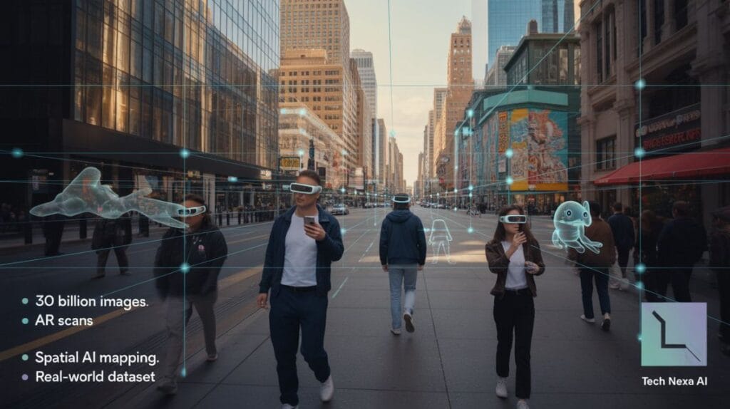
On a busy Saturday afternoon in Chicago’s Millennium Park, tourists held up their phones to capture photos of Cloud Gate. A few feet away, teenagers were spinning PokéStops and scanning landmarks for in-game rewards. To most passersby, it looked like harmless nostalgia — a 2016 gaming craze that never fully faded. What almost no one realized: those casual AR scans were quietly feeding one of the most ambitious real-world mapping datasets in artificial intelligence.
That revelation is now coming into sharper focus as Niantic confirms that photos and augmented reality scans collected through Pokémon Go have helped generate more than 30 billion real-world images. For a mobile game company, that number is staggering. For the AI industry, it’s strategic gold.
From Gaming Hit to Spatial Data Engine

When Pokémon Go launched in 2016, it was positioned as a location-based mobile game powered by nostalgia and novelty. Underneath the surface, though, Niantic had a bigger ambition: building what it calls a “real-world metaverse” grounded in geospatial computing.
Niantic wasn’t starting from scratch. The company emerged from Google’s internal startup incubator, and its earlier game, Ingress, had already trained players to map real-world locations. Pokémon Go dramatically scaled that model. Instead of thousands of hardcore players, it suddenly had over 100 million monthly users at its peak.
The shift from gameplay to spatial data collection wasn’t obvious at first. But features like AR scanning, location tagging, and image submissions weren’t just engagement tools. They were structured data acquisition mechanisms.
How 30 Billion Images Actually Matter
To understand why this matters, you have to think beyond gaming. AI systems that interact with the physical world — autonomous robots, AR glasses, delivery drones — need spatial awareness. They need to understand depth, surfaces, lighting, and context.
Text data trained large language models. Image data trained computer vision. Spatial data trains machines to navigate reality.
Thirty billion geotagged images, collected across diverse lighting conditions, seasons, and angles, create something rare: a continuously updated 3D understanding of the real world. Not static maps. Living maps.
In cities like New York, Los Angeles, and Dallas, players repeatedly scan landmarks, storefronts, and public art. That repetition helps train AI systems to recognize structures even when signage changes, trees grow, or construction alters a facade.
The Economics Behind “Free” Gaming
Pokémon Go has always been marketed as free-to-play. Revenue comes from in-app purchases — raid passes, cosmetic upgrades, event tickets. In 2020 alone, the game generated over $1 billion in player spending.
But the deeper economic model has two layers.
First, direct monetization through players. Second, long-term monetization through data infrastructure. A company sitting on one of the world’s largest real-world spatial datasets holds leverage in AR advertising, location intelligence, robotics partnerships, and enterprise licensing.
This isn’t sinister. It’s strategic. Silicon Valley learned long ago that data compounds in value.
Players thought they were collecting Pikachu. In reality, they were contributing to a machine vision training pipeline.
What This Means for U.S. Consumers

Most American players never worried about data implications. The scans felt optional. Rewards were minor. The gameplay was the draw.
But as AR devices become mainstream — from Meta’s smart glasses experiments to Apple’s spatial computing ambitions — real-world mapping becomes foundational infrastructure. Whoever owns accurate, dynamic 3D maps holds a powerful advantage.
For consumers, that could translate into smoother navigation overlays, more immersive retail experiences, and better accessibility tools. Imagine AR glasses that guide visually impaired users through complex transit hubs using richly trained spatial models.
There are benefits here. Real ones.
The Privacy Trade-Off
Still, scale changes the conversation.
Thirty billion images raise inevitable questions about consent, transparency, and secondary use. Even if scans focus on public landmarks, they capture surrounding environments — storefronts, signage, foot traffic patterns.
Niantic states that scans are used to improve AR experiences. But history shows that datasets often evolve beyond their original purpose. Once spatial maps reach a certain fidelity, commercial applications multiply.
The United States does not yet have comprehensive federal data privacy legislation comparable to Europe’s GDPR. Regulation remains fragmented. That leaves companies with broad operational flexibility — and consumers with limited visibility.
Industry Context: Why Spatial AI Is Heating Up
The AI conversation over the past two years has centered on generative text and image models. Quietly, though, venture funding has surged into robotics, computer vision startups, and geospatial AI platforms.
Autonomous delivery companies need accurate sidewalk maps. Warehouse robots require centimeter-level spatial awareness. AR developers need persistent anchors in the real world.
Building that infrastructure independently would cost billions. Niantic crowdsourced it through gameplay.
It’s an elegant model — if you admire startup efficiency.
Practical Example: The Retail Overlay Scenario
Consider a retail district in Austin. If Niantic’s spatial maps understand storefront geometry and pedestrian flow patterns, AR advertising becomes more contextual. A future AR headset could overlay real-time promotions on a café entrance as you approach.
That’s valuable to advertisers. It’s convenient for some consumers. It’s intrusive for others.
The line between helpful augmentation and visual clutter will define public acceptance.
What Most Articles Miss
Most coverage frames this as a clever accident — gamers unintentionally training AI. That oversimplifies the strategy.
Niantic has spent years repositioning itself not just as a game studio, but as a spatial computing platform. It has launched developer tools and pitched enterprise AR solutions. The dataset wasn’t incidental. It was compounding infrastructure.
Also overlooked: retention. Pokémon Go’s staying power ensured ongoing data refresh cycles. Static maps age quickly. Living games keep maps current.
The Limitations of Crowdsourced Mapping
For all its scale, the dataset isn’t perfect.
It’s concentrated in urban and suburban areas with active player bases. Rural regions likely remain under-mapped. Socioeconomic disparities in smartphone usage may create uneven spatial representation.
Lighting bias, weather conditions, and user device quality also affect data consistency. Not all scans are equal.
In AI training, noise matters. Billions of images reduce error rates — but they don’t eliminate them.
Market Implications
If Niantic successfully monetizes its spatial dataset beyond gaming, it could transition into a hybrid infrastructure company — part entertainment, part mapping platform.
That would place it in indirect competition with established mapping giants and emerging AR ecosystems. The U.S. tech market tends to reward infrastructure plays with recurring enterprise revenue over volatile consumer gaming cycles.
Investors understand that data moats are defensible. Games alone are not.
Looking Ahead: Hype vs. Reality
Will this dataset single-handedly power the “metaverse”? Unlikely.
Will it meaningfully contribute to the next generation of AR and robotics systems? Probably.
The future of spatial computing won’t be built by one company. It will be stitched together from overlapping datasets, sensor networks, and AI models. Niantic has carved out a meaningful piece of that puzzle.
The real question is whether consumers will remain comfortable contributing to it — knowingly or not.
FAQs
1. Did players explicitly consent to their AR scans being used for AI mapping?
Players agreed to terms of service that permit data usage to improve products and services. However, few likely anticipated the long-term scale and cross-industry implications of spatial dataset development.
2. How valuable is a 30 billion image spatial dataset in financial terms?
While precise valuation is speculative, large proprietary datasets can represent significant competitive advantages in AI infrastructure markets, particularly if licensed to enterprise partners.
3. Could this data be used for advertising?
Potentially. High-fidelity spatial maps enable contextual AR advertising overlays, though implementation would depend on business strategy and regulatory scrutiny.
4. Is this different from traditional mapping services?
Yes. Traditional maps focus on navigation and satellite imagery. Crowdsourced AR scans create ground-level, 3D spatial awareness useful for machine interaction, not just human directions.
Editorial Reflection
Pokémon Go may be remembered as a cultural moment — a summer when parks filled with players chasing digital creatures. But its longer legacy could be infrastructural. Beneath the nostalgia sits a case study in how entertainment platforms quietly build the foundations of emerging technology markets.
The Pokémon were visible. The mapping wasn’t. And that’s what makes this story worth paying attention to.